Tag Archives: tiger bay

Cardiff in the Eighties – by Nick Sarebi

I recently spent a few hours lost in the internet when I came across Nick Sarebi’s wonderful photographs of Cardiff in the 1980s. I messaged Nick who kindly agreed to let us publish them, and even did a mini interview with me, which I present, here, for you. Do enjoy this wonderful dip into the archives, back into Cardiff in the late 1980s and very early 1990s. Over to Nick …

Nick: I originally came from London. I lived in between Grangetown 1988 – 95, although I was still working in London for much of that time. I always thought Cardiff was a lovely city.

I was doing a City and Guilds photography project at the time. I loved the sense of history that the Docks had, and obviously it was just on the cusp of change. I wish I took more photos back then, but it was before digital.

I lived in Pentrebane Street in Grangetown. I remember my neighbour saying that she knew Shirley Bassey and went on a works outing with her, where she sang, but then again everyone claimed to know her at that time! I think there were still close-knit families in Grangetown then, which was changing at that time. The neighbours were all very friendly. The house was covered inside with Artex when I bought it. It took ages to scrape off, I must have been mad!

The Docks

Cardiff docks, taken around 1990
Imperial House, which disappeared sometime in the 1990s
The dry dock, photographed in the 1980s. The dry dock is still there, but the shed has long since been demolished.
Cardiff Docks, taken in 1990


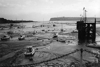
Nick: I loved wandering round the Docks at that time, before it was all developed. It was pretty much deserted at the time. I also remember visiting the Sea Lock and some other Docks pubs. I wanted to go into the clubs down there but was a bit wary as an outsider. The Sea Lock was definitely stepping into the past. The main bar was closed and they only had a tiny bar left open. They frowned on women going in there alone! It was demolished soon after, I think. The publicans were really friendly. I recommend Trezza Azzarardi’s The Hiding Place – it’s a brilliant take on Tiger Bay. It conjures up Tiger Bay so well for me I had to go back and take another look. It was criminal how the knocked the place down. It can still be seen in the classic film Tiger Bay, which you should watch if you haven’t seen already.

There’s a nice interview with Neil Sinclair here, talking about the story of the place that inspired the Tiger Bay musical that was out year  …

I remember meeting Neil Sinclair, who is at the start of Tiger Bay talking with Hayley Mills. We met at a nice pub which was on the Bay front and was very isolated, out on the way to Penarth. This was before they built that flyover. I forget its name, I think it must have gone now.

Butetown, Cardiff 1991. This building is now home to Octavo’s bookshop and cafe
The Dockland Mini-Market – which can still be seen on James Street today
This building was preserved in the Docks redevelopment – you can now see it as the entrance to the Waterguard pub
The famous clock from the famous Coal Exchange – which, after years in disrepair, is now the Exchange Hotel
The infamous Casablanca Club, long since demolished
Cardiff docks … taken in 1991
The Norwegian Church, 1990
Windsor Esplanade, early 1990s
Cardiff Bay redevelopment, early 1990s

Cardiff – the city

Nick: Why did I move to Cardiff in the first place? That’s a good question. I wanted to move out of London, as it was expensive to buy a house there (even then!) and it was so big. Of course, no one could imagine that house prices would rise to the crazy levels they are now…

I couldn’t decide on Bristol or Cardiff. My girlfriend at the time lived in Bristol, but we split up just before I moved, so I chose Cardiff. In retrospect, what was mad was not looking for work in Cardiff. So I just travelled thousands of miles up and down the M4!

Eventually after Cardiff I moved to Bristol and I worked there for a couple of years, but was offered a part-time job in London, which went from two to four days, so I started commuting again, from 1997 right through to 2013.

I now look back and wonder why I did that! I spent seven years in Cardiff, but somehow it doesn’t feel that long – it flew by. I arrived in Cardiff only a few months after Lynette White was murdered. Someone wrote a book on it called Bloody Valentine, but it had to be pulped for libel reasons.

Tremorfa, around 1991
Seriously – whatever happened to Mr Sandwich?

Nick: It was a bit ridiculous travelling backwards and forwards to London for all those years I lived in Cardiff. Cardiff was all changing at that time. I studied at the Arts Centre – I can’t remember what it was called now.

I have visited Cardiff a few times since I lived there, walking all round the barrage with my son, and have been to watch my team, Fulham, play Cardiff. It always brings back memories. I’m glad I lived there when I did, and saw the bay before it became “the Bay”.

***

Thank you so much Nick! He has a couple of really great albums of 1980s photography. We particularly love these albums:

Miners strike 1984 (photographs of mining families on holiday in London during the strike)

St Pancras Station 1980-1 (some great portraits of rail workers as well as general shots from around the station)

London Docks (images from the 1980s to now)

And of course, his Cardiff in the Eighties album in full.

To see more of his photography, visit Nick’s Flickr page.

***

The history of Clarence Bridge and William Harpur

My latest post for Caught By The River was published recently, for my Wandering the River Taff column. In it, I explored the history of Clarence Bridge, which connects the wards of Butetown and Grangetown. I always end up doing about ten thousand percent more research than I can fit in the columns, so get ready for all the interesting extra bits I couldn’t cram in.

The basic history of the bridge is documented in the piece:

A wooden swing bridge went over the Taff, about a hundred or so metres south of where the bridge is today, joining ‘Lower Grangetown’ to the Docks. This bridge connected the areas from 1861 to 1890 – the period when the docks started booming. Increasing numbers of people started using the bridge to get to work from Grangetown, but the Taff Vale Railway Co leased the bridge privately, and started charging for its use.

(Map: Glamorgan XLVII, surveyed: 1878 to 1879. Published: 1885)

Towards the top right of the picture, you’ll see James Street running horizontally across (it’s where you’ll find the police station today). If you stretch that line out directly to the left, you’ll find the current location of Clarence Bridge.

I did quote from the wonderful Grangetown Cardiff’s history section in my column, but I didn’t manage to get all the details in. On the day they introduced the toll, local residents rioted and threw the bridge’s gate off its hinges and threw it in the river.

The Times reported that 1,000 men took part in the protests each day against the railway company. There had been “upmost good humour” for the most part, as 200 police stood by, but then there was direct action. “They rushed at the newly-erected toll gate and tore it from its hinges, throwing the structure in the river.” The first gate was replaced the following day, as well as a sentry box for the toll-keeper. The toll house was also damaged. The paper later publishes court reports of three men who were arrested for causing the damage, costing £5 – Cornelius Dacey, William Smith and William Webb, all under 23. Police were also after another man called William Drew, who was heard to shout “Go it boys, that’s right, pull it off!” The court was told of “200 armed navvies with iron bars up their sleeves.” The three were found guilty and the judge expressed sorrow at having to sentence them to a month’s hard labour.

Eventually the Cardiff Corporation relented to the chaos and built two proper public access bridges – Clarence Bridge, which spanned the River Taff, and the James Street Bridge, which spanned the Glamorganshire Canal. You can see both these bridges appearing in maps from 1898 onwards. Also note the original wooden swing bridge has disappeared – been dismantled by this point, leaving Hamadryad Road cut off abruptly by the Taff.

(Map:Sheet 263 – Cardiff (Outline) Published: 1898)

If you want to see the location of the original wooden bridge, head to Hamadryad Road on the Butetown side. You can’t reach the Taff directly as there’s a big fence up, but if you face the water, you’ll be standing roughly where that original bridge was – well over 100 years ago. It had cost £60,000 when it was originally built.

Grace’s Guide shows the original plans for the bridge, which was designed by William Harpur. I’d never heard of him before, but turns out he’s a fairly important figure in Cardiff’s modern history.

Some more lovely photos that were posted in the Cardiff – Now and Then Facebook Group by David Lawson:

Clarence Bridge construction, 1898


The original Clarence Bridge, mid swing

William Harpur, the bridge’s engineer, is not really a household name, but modern Cardiff has his fingerprints all over it. He was appointed Borough Surveyor in 1883, and as such had final and ultimate say over all proposed street layouts and individual buildings that were going up through the city’s boom years.

If you’ve walked down Castle Street, visited Cardiff Indoor Market, or been to Roath or Victoria Parks, you’ll have first hand experience of his work. There’s also the civic centre at Cathays Park, the widening of the Hayes and Working Street. He built the city’s first municipal hospital (the Hospital for Infectious Diseases – later Landsdowne Hospital) and also the Pumping Station – now an antiques market.

Harpur was also engineer to the tramways department, and carried out the construction of the track for the electric cars. As his obituary so delicately puts it, his mark is left on the lay-out of every inch of modern Cardiff: all the plans of new roads, buildings, bridges etc having had to receive his approval.

William Harpur – 1853-1917, Cardiff city engineer and surveyor

Bit of a hero, William Harpur. Good beard too.

Read all of my entries about the Taff in my Caught By The River column

***

Caught By The River – This is Rat Island

So, you guys. I’ve recently started a column for the wonderful Caught by the River website, based on my wanderings (and wonderings) around and about the lovely River Taff.

Read my first instalment here: Wandering the Taff: This is Rat Island

I know, can’t I write about anything other than Cardiff, amirite? Anyway, two weird things happened after the piece was published. Firstly, after living on the edge of south Cardiff on “Rat Island” for nearly seven years and having NEVER seen a rat down here, I saw TWO within the space of two days – one running across the car park in Morrisons and one scurrying around in the bushes on Dumballs Road.

Wait … there’s more … secondly, what I thought was just a little bit of basic desk research into what is essentially a fluff piece about the place I live got way more complex. It turned out to be the question that kept questioning, itself, other people, and me.

In the piece I wrote for Caught by the River, my conclusion was that no one really knows where Rat Island was exactly, but that we have a rough idea (based on all my research): it was the land that lay between the River Taff and the Glamorganshire Canal, to the south of where Clarence Road Bridge is now.

This is the conclusion I had come to from all the many things I’d read, personal accounts, articles on the BBC, Wales Online, modern history books, etc. Fine.

You can’t actually see Clarence Road Bridge in the map below – it hadn’t been built at this point (1879). But roughly halfway down the picture, you can see James Street on the right hand side – imagine that carrying on to the left (westwards) and going straight over the water into Grangetown. That’s the horizontal line we’re talking about, just above where it reads ‘Dumballs Marsh’.

rat-island-location

(Map: Glamorgan XLVII (includes: Cardiff; Penarth; St Andrews Major – surveyed: 1878 to 1879, published: 1885)

But no, not fine. Writer, poet, historian, all-round good guy Peter Finch has done all of the due diligence with respect to Cardiff history when researching for his Real Cardiff books (recommended reading, students), and he responded to an email I’d sent him asking if he knew where the spot was with this: the general area was right – it was between the Taff and the canal, but rather than being south of where Clarence Road would eventually be built, it was actually north (up towards where the centre of town is): in between that bridge and the timber ponds, on an actual island created by the Taff, oxbowing its way down to the Severn and the sea beyond.

Peter, wonderfully poetic even when answering inane questions from Cardiff bloggers, wrote me this:

The Taff has always moved about. Thrashed about perhaps, as it traverses its delta. Rat Island, as I understood it, was a section of Taff’s bank made an island by the river ox bowing itself. This was  upstream of Clarence Road Bridge near The Dumballs. It was formed, according to Mary Gillham, following one of the periodic floods that plagues the Taff. Gulls and other birds nested there. Rats invaded along a revealed at low tide causeway in order to steal their eggs. The land became rat infested. The name followed.

That was Peter’s first email. Isn’t he a gem? Being in a mad rush, as I always am, I misread the ‘upstream’ part and thought he meant downstream …

But there’s a reason for that. All of the folks I asked – people who used to live here, and had the story handed down from parents or grandparents – had heard the area was called Rat Island because of the rats that were disturbed either when the HMS Hamadryad first to the area (in 1866), or when she was finally dragged away to be destroyed in 1905.

Even once the initial piece was published, I had some tweets also corroborating this theory:

It makes sense, but the area being referred to is south of the Clarence Road Bridge: quite a lot further south … and adding to the confusion, I had read somewhere else the area was already called Rat Island, long before the ship came to Cardiff in 1866.

So how does it all fit together?

The discrepancy between the locations – north of the Clarence Road Bridge, versus south?

I raised the possibility of the name referring to an area north of the bridge with the Cardiff Docks Remembered Facebook (where people share memories of the area and discuss such matters) and it was pretty much universally poo-pooed. No way, said people who had grown up around here. Their truth was in the tales from their parents and grandparents, and they had been definitively told. Rat Island was south, the area next to the Sea Lock, that would eventually turn into Hamadryad Park.

We aren’t debating the European Convention of Human Rights or anything here guys. I am well aware this is a long gone name for an area that bears no resemblance to the marshy hinterland that inspired it – but that doesn’t stop me wanting to know WHY, does it??

There is, I think, anyway, a solution to this, that includes all of these seemingly conflicting perspectives and accounts: an ultimate answer that I – Helia Phoenix, non-historian, non-expert, super-nosey local person – will put forward as the only conclusion to this burning issue … this imperative question … that literally no-one – apart from me – is asking …

Where was Rat Island?

Here’s my theory. The entire area that fringes the main urbanised docklands – from the Bute Ironworks all the way to the south and east, where you can see the HMS Hamadryad hospital ship – would have been a muddy, marshy wasteland at that time – its only purpose really to keep people with infectious diseases away from the overcrowded docks and Tiger Bay. There was very little of interest on any of that land – either north of the future Clarence Road Bridge, or south of it.

So … it’s possible that the one spot was originally named ‘Rat Island’ – the small island next to the Ironworks, as pointed to by Peter Finch – but the name spread down (or was re-used) in the south, once the HMS Hamadryad showed up (or was hauled away), spreading its ratty citizens across the undergrowth that is now Hamadryad Park.

hamadryad_hospital_ship
HMS Hamadryad Hospital Ship on “Rat Island”, Cardiff. Photo from People’s Collection Wales

I won’t hold out for my Nobel Prize. But I did feel like I might have actually sort of solved something that’s been bugging me for ages.

I emailed Peter asking if he thought this might be possible. He agreed – that there were two things that were getting confused here …

Rat Island, the geographic island, i.e. a piece of land with water on all sides is the place you’ve spotted on your map. This is the one Mary Gillham suggests had birds nesting on it whose eggs were stolen by rats. Then there’s the local name for the whole district. Bill Barrett who died in 2013 and who was writing his piece on Rat Island for the Cardiff Book #3 (Stewart Williams Publishers)  in 1977 suggests that all the land between the canal and the Taff was known as Rat Island. He suggests that this went as far north as the Timber Ponds. These were where the Iron Works are shown on your map … it does seem to be probable that the whole slab of land took on the name of the island. 

So, Bill Barrett (RIP) might have got there before me. I wasn’t able to find a copy of his book anywhere (I’m on the lookout – please tell me if anyone finds one), but I’m happy enough with the result.

I did a lot of research for the initial piece (though it might remain inconclusive…), so if you’re interested in further reading:

Canal Park and Sea Lock Pond (Stuart Herbert)

The Hamadryad Hospital Ship (BBC Wales History Blogs / Phil Carradice)

#towerlives: Rise of towers and fall of Tiger Bay (BBC)

The Cardiff Coal Boom: The Chronicle Radio show (featuring Ian Hill from Save the Coal Exchange, author / historian Neil Sinclair, Juliet Lewis – Senior Lecturer at the Welsh School of Architecture), broadcast February 2017

Not really relevant for this piece, but lovely to follow if you’re on Twitter: @OldCardiffPics

Big thanks also to Peter Finch for indulging me. His latest book, The Roots Of Rock From Cardiff To Mississippi And Back, is available from Seren now, priced £9.99. View Peter Finch’s archive.

Images in this piece: both taken on the section of the Taff that runs through the now disappeared Rat Island: Instagram malayabbasi and heatherpatterson.

***


#towerlives: a festival of storytelling and music in Butetown

#towerlives is a week-long festival of storytelling and music, on air and on the ground, around the council estate tower blocks of Butetown in Cardiff. How fabulous!

BBC Wales, 1XTRA, Radio 2 and News Online are collaborating all week with documentaries, news reports, features, comedy, spoken word and music.

#towerlives

Ceri Jackson has written this in-depth and beautiful piece about #towerlives: Rise of towers and fall of Tiger Bay (it’s a great long-read): “By the later 1800s Butetown had taken on its unofficial name as the legendary Tiger Bay, the source of tales once told by sailors around the world. “Local folklore has it that there was a woman who used to walk around Loudoun Square with two tigers but then seamen were known for their tall tales,” says Neil. “Portuguese sailors are believed to have come up with the name. The tides in the area are notoriously difficult. After successfully docking they would say that sailing into Cardiff was like sailing through a bay of tigers. And so it was – Tiger Bay stuck.” Another theory is that its reputation as a wild hotbed of hedonism, rough house boozers, crime, prostitution and illegal gambling earned it sole use of a once generic term long used by sailors for raucous ports everywhere. Some of the nicknames given to the area’s 97 pubs – House of Blazes, Bucket of Blood, Snakepit – infamous for brawling sailors and prostitutes could add some weight to that.”

Cardiff comedian Leroy Brito explores the curious dialect that is spoken there (watch the video on this page:#towerlives: Leroy Brito in Butetown ‘talking Butetown’

Chris Walsh-Heron’s blog – telling the story of life on a high-rise estate: “The old Tiger Bay had a fearsome reputation for danger and debauchery. But if you dared to venture into the dockland streets, you’d stumble across the whole world in just one square mile. The laughter from the late-night Maltese cafes would echo down lanes full of Chinese laundries, Arabian tea houses and Caribbean dancehalls, where sailors from Cyprus, Somalia and Sierra Leone would be trying their luck with the local Welsh girls.”

#towerlives

Looks great – and how awesome for this part of the city with such a diverse community to get this kind of coverage.

More please! #towerlives

Butetown History and Arts Centre

Butetown history

***

Sign up for the weekly We Are Cardiff newsletter

Check out what’s going on with We Are Cardiff Press

Like us on Facebook

Squawk @ us on Twitter @wearecardiff

Follow us on Instagram/WeAreCardiff

Cardiff on camera … watch ‘Tiger Bay and the Rainbow Club’ (1960) #BritainOnFilm

Who doesn’t LOVE seeing archive footage of the city? The British Film Institute (BFI) have recently released a load of films from their archives, including a number based here in Cardiff.

The first one is ‘Tiger Bay and the Rainbow Club’

Tiger Bay and the Rainbow Club screenshot

This film offers a great portrait of the communities in the city in the mid-60s. It was made by Malcolm Capener who was both Chair and Secretary of “South Wales Films”, a film-making club for amateurs. He shot footage of Tiger Bay, recording both the activities of The Rainbow Club – set up to encourage the children of the docks area to participate in the performing arts – and the varied range of cultural festivities and events that took place there over a period of years. Tiger Bay was home to people whose origins spanned the globe and who had established a successful, integrated society – very few films from black, Arab and Asian families living in the UK at this time have made their way into our collections, so this is a particularly important find.

Malcolm Capener, Roath-based proprietor of the Welsh Travel Company, Bute Street, Cardiff, was chair and secretary of South Wales Films, a filmmaking club for amateurs. He shot footage of Tiger Bay (part of Butetown), recording both the activities of The Rainbow Club and the wide range of cultural festivities and events that took place there over a period of years. Tiger Bay was renowned as an ethnically diverse area of the docks, home to people from across the globe who had established a successful, integrated society in Wales’ capital city.

National Screen and Sound Archive of Wales preserves and celebrates the sound and moving image heritage of Wales, making it accessible to a wide range of users for enjoyment and learning. Its film collection reflects every aspect of the nation’s social, cultural and working life across the 20th century, giving a fascinating insight into Welsh filmmaking, both amateur and professional.

From Britain on Film available at BFI Player

***

Sign up for the weekly We Are Cardiff newsletter

WATCH: Cardiff, a stroll through Tiger Bay

Gotta love these old films!

Published by Cardiffians on YouTube: ‘Author of the Tiger Bay Story and The Cardiff Bay Experience, Neil Sinclair brings to the screen his very popular seafront history walk. Now in the pleasure of your easy chair you can venture down the old Georgian, Victorian and Edwardian streets of Tiger Bay and The Docks as they were.

‘Hear also interesting anecdotes of the larger than life characters who once walked those no longer existent streets and see how Cardiff, a mere village with less than 2,000 dwellers, grew into the city we recognise today.

‘Neil, who also does lectures, presentations, exhibitions and bus tours for the Cardiff Bay Development Corporation, is a well known personality in the Bay where he still lives. In collaboration with Director Fran Boyer of Moaning Minnie Productions and underscored with original music composed by local musician and artist John Lenney, Neil has produced a most exciting and interesting video.

‘Contrasting wonderful views of Cardiff’s newly transformed seafront with historical film footage and archive photographs, this video revives the historic beginnings of Cardiff’s turn of the century rise from obscurity, inspired by the foresight and auspices of the Second Marquis of Bute, to become the world’s most famous seaport.’

Cardiff docks, image from urban75.org

“Cardiff Bay – what’s in a name?” – Jeremy

jeremy-rees-web

I get out and about in Cardiff quite a bit, it goes with the job. Unsurprisingly, then, I’m often asked the question ‘where do you live?’ It’s a fairly humdrum, commonplace way to initiate small talk. For some people the reply to such a query would roll off the tongue without a second thought. In my case though, it’s not such a straightforward matter….

For the record, I live in a terraced street in a cluster of Victorian houses near where the River Taff ebbs and flows its way towards the Bristol Channel. The houses on my street were built to accommodate the families of men working in what was one of busiest seaports anywhere in the world. The houses all look pretty much the same from outside, but all are built slightly differently – some quite considerably larger than others to reflect more senior positions of the inhabitants, with the Sea Captain’s houses being the largest. The house I live in is one of the smaller ones and was home to a docker’s family for 65 years. That family has gone, but the stories of their time here lives on in the memories of my neighbours who have lived on the street for decades. It’s a friendly and welcoming place to live; the community is richly diverse in ethnicity, and that’s nothing new – the area is part of what many regard as the oldest multi-cultural community in Britain. To those who’ve lived here for generations, this area is known simply as ‘The Docks’. Separated from what used to be Tiger Bay by Clarence Road, it’s a small enclave that survived both the bombings of World War 11 and the brutal bulldozers of Cardiff Corporation in the 1970s.

To call it ‘The Docks’ is a nod to its history, its heritage – to the stories of the people who lived and died here, but it can’t be denied that the name no longer reflects the area. What remains of Cardiff Docks is a good couple of miles away, and the only vessels we now see calmly making their way down to the barrage are yachts and the occasional Water Bus. Estate Agents have applied the term ‘Cardiff Bay’ to these streets for 20 years or more, and unsurprisingly that’s how many others of my neighbours describe where they live. The street is a stone’s throw from the heartland of ‘new’ Cardiff – the Wales Millennium Centre, Mermaid Quay, The Red Dragon Centre and the profusion of restaurants and arty shops that have transformed this once neglected part of the City into a thriving cultural hub. For me, though, all the impressively shiny newness is a stark counterpoint to what it replaced. The decaying but still majestic empty buildings at the top end of Bute Street and the abandoned railway station in the Bay are screaming out for investment while new constructions – which could be anywhere in the UK – are still springing up.

As far as maps – and Cardiff Council – are concerned, I live in Butetown. The area of the City about which most books have been written, and which inspires reactions as diverse as the district itself from people who have never been here. It is in Butetown that Cardiff’s only community radio station has its studios. Indeed, Radio Cardiff is the only radio service exclusively aimed at the city. It’s an extraordinary operation. It receives no grant aid and employs no staff, but has a team of over 50 unpaid volunteers who put together programming that is quite unique and with a definite Cardiff accent. The team behind it ran short-term restricted licence broadcasts (under the names Tiger Bay FM, Bay FM and latterly Beats FM) regularly from 1992, and then in 2007 succeeded in winning the licence to broadcast the full time ‘Radio Cardiff’. I joined at its official launch, first as a newsreader and then as a presenter. Now I co-ordinate the volunteers who produce the news output and a youth programme. I also present the Saturday Breakfast Show. It’s more than a radio station for the community, it’s a community within itself – multi-cultural and across age ranges. I have learned so much from being part of the team there, not just about radio but about the city in which I live. I have been privileged to meet – and often interview – many of the people who have contributed to make Cardiff what it is today.

So, just where do I live? I totally respect the idea of referring to my area as ‘The Docks’ but in truth it’s a name that reflects a time I wasn’t here and so it doesn’t really feel right. I’m not a ‘Docks Boy’ – I grew up in the Swansea Valley and lived much of my adult life in London so while I love hearing the stories of its past, they are not my stories. I’m uncomfortable with calling it ‘Cardiff Bay’ perhaps because of what was cleared away to create it – it’s still raw for many who grew up in Tiger Bay that the unique community that meant so much both to them and to the city could have been swept away by a planners blueprint. I have no problem with the name Butetown other than it refers to the larger district, and so whatever the Post Office may say, I live in ‘The Bay’,

Jeremy Rees works for Voluntary Action Cardiff, – the organisation supporting charity & voluntary organisations in the City – and at Radio Cardiff where he presents ‘Soulful Saturday Breakfast’ every Saturday morning 7am-9am. He currently lives in the Bay.

Jeremy was photographed at the Radio Cardiff studios by Adam Chard

***